Join Us in Nashville: Meet Our Livestock Industry Experts At CattleCon 2026!
Book a Meeting >
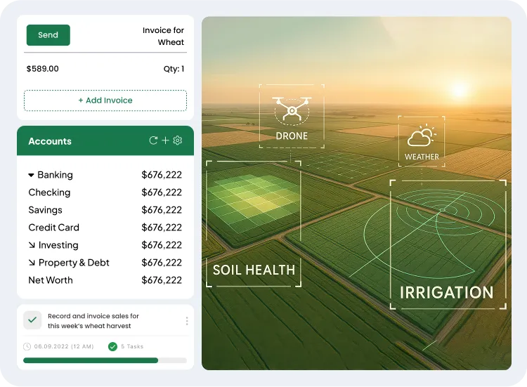
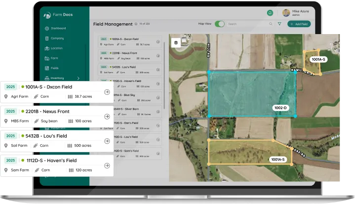
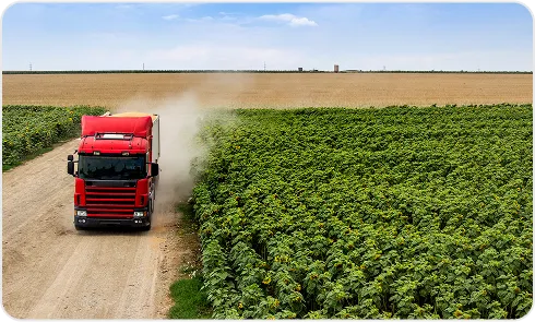
Manage Real-Time Field Data at Scale with AI-Driven Crop Management Software
Reduce reliance on manual tools by switching to a crop management software that centralizes operational data, enables real-time field monitoring, supports zone-level planning, and drives precision decisions from planting to harvest.
Large-scale crop operations face unpredictable conditions, resource constraints, and data overload; using integrated software simplifies management.
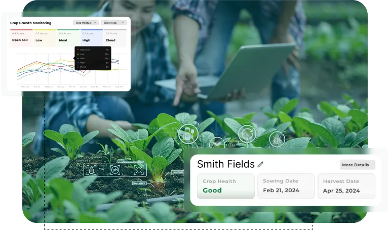
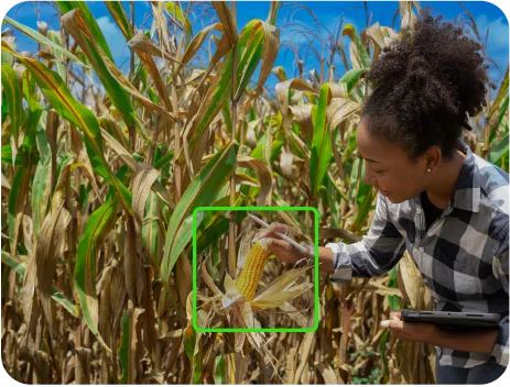
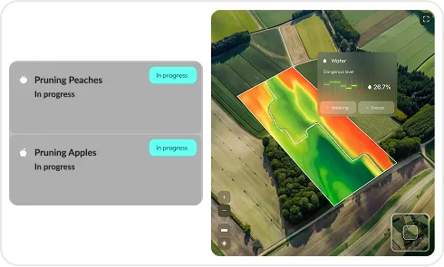
Lack of Real-Time Crop Visibility
Challenge
Without real-time, detailed crop health and yield data, large farms struggle to target interventions and maximize returns across varied field zones.
Solutions
Live Crop Health Monitoring
Satellite & Drone Integration
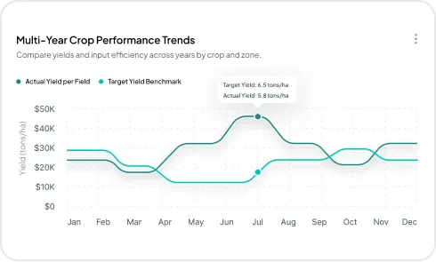
Yield Mapping & Analytics
Field Condition Alerts
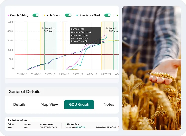
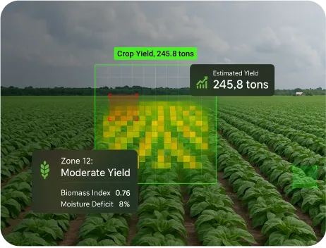
Poor Harvest Planning Causes Waste
Challenge
Mismatched harvest timing across zones leads to labor clashes, overloaded trucks, or storage shortages, especially when yield estimates aren't tracked in real time.
Solutions
Zone-Based Maturity Tracking
Harvest Crew Scheduling
Yield Estimate by Field
Storage & Transport Mapping
Poor Financial Tracking Limits Profitability
Challenge
Tracking per-acre costs, margins, and ROI by crop is complex when data is scattered across tools or departments.
Solutions
Per-Acre Cost Tracking
Integrated Budget Management
Crop ROI Analytics
Expense & Revenue Reporting
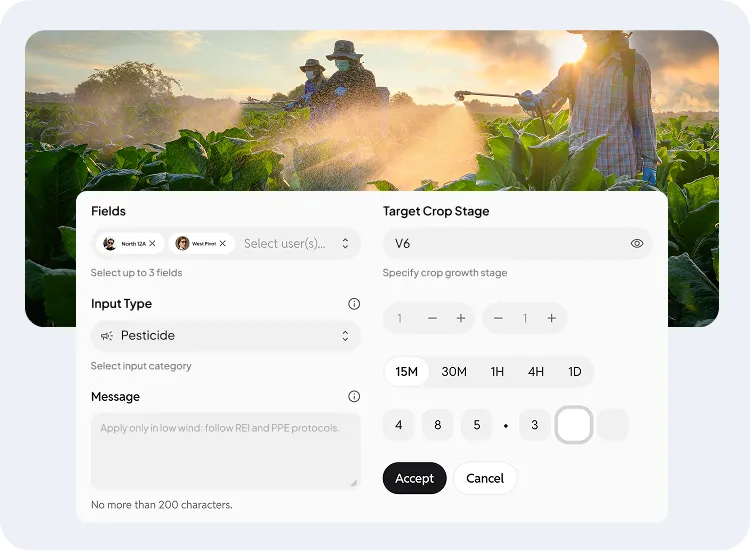
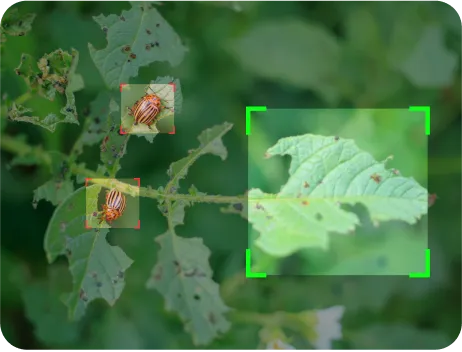
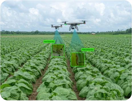
Delayed Pest Detection Increases Damage
Challenge
Scouting is often inconsistent across fields. Delayed entries mean pest pressure builds unnoticed, and treating it becomes costlier and less effective.
Solutions
Pest Scouting Logs
Treatment History Records
Threshold-Based Alerts
Scouting Task Scheduling
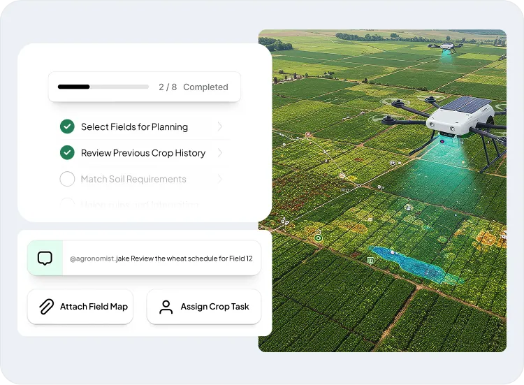
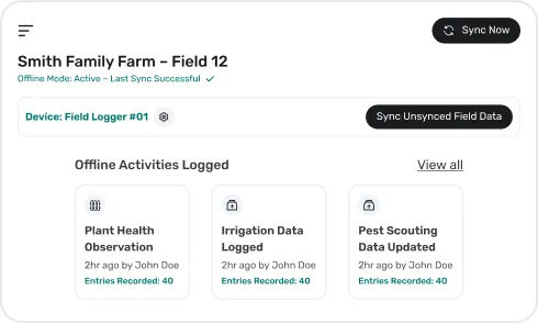
Scattered Data Blocks Field Insight
Challenge
Data from scouts, sensors, and machinery often lives in silos, making it hard to align agronomic decisions with execution.
Solutions
Unified Data Dashboard
Mobile Field Reporting
Sensor & Device Sync
Task Data Integration
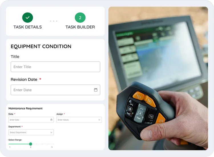
Your Single Solution For End to End Crop Management
Handle planting, input use, irrigation, and farm costs through specialized, synced crop management software modules.
Breeding Management
Track, evaluate, and manage seed production activities from cross design to varietal performance.
Track parent lines, pollination dates, and cross combinations.
Record germination rates and seed viability by batch.
Monitor varietal performance using GDU, vigor, and phenotypic traits.
Geotag trial plots for spatial performance insights.
Run your crop business better with custom-built crop management software that maps to your role, whether you are a crop grower, processor, or distributor.
Breeders & Seed Producers
Drive faster variety trials and track germination using data-driven seed management tools.
Large-Scale Crop Growers
Optimize planting and harvest with predictive insights and scalable field monitoring solutions.
Greenhouse
Manage controlled environments with real-time climate data and crop growth monitoring tools.
Post-Harvest Processors
Monitor lot intake, hulling, shelling, and packing stages with detailed traceability.
Ag Retailers & Distributors
Optimize inventory and supply chain forecasting with integrated demand and customer analytics.
Transportation & Logistics Providers
Ensure cold chain integrity and route efficiency via real-time tracking and alerts.
Real-world examples of leading crop businesses showcasing the impact of our custom crop management software.
Our modules of TRUETRAC empower agribusinesses to navigate supply chain complexities, delivering precision, ensuring compliance, and providing full transparency.
Growers Express partnered with Folio3 to boost efficiency by implementing AX Mobility Solutions, improving data access, automating tasks, and enhancing compliance and visibility.
A mobile-first inspection platform was built for ICIA, featuring GPS-enabled workflows, real-time notifications, task tracking, and PDF exports to automate and digitize crop inspections.
AI-powered analysis of aerial imagery enabled city planners to accurately track urban forest cover, reduce survey costs, and drive smarter, sustainable green infrastructure planning.
A satellite-integrated system with AI and geo-fencing enabled real-time plant health monitoring, reducing manual effort by 90% and enhancing compliance across expanding plantations
An AI-powered platform combining satellite imagery and geo-tagged data delivered real-time plantation visibility, helped in detecting growth issues early, and reduced manual monitoring across large-scale operations.
Partners & Affiliations
Frequently Asked Questions
What is crop management software?
It’s a digital tool that helps plan, monitor, and manage crop operations. You can use the software to schedule tasks, track inputs, monitor field performance, and centralize data across teams and locations.
What technology is used to monitor crops?
Modern crop monitoring uses a mix of satellite imagery, drones, field sensors, GPS, and AI. Together, they give you a real-time view of what’s happening in your fields, whether it’s plant stress, soil moisture, or weather impact.
How does crop monitoring software utilize satellite imagery and sensor data to track crop performance in real time?
The software pulls in satellite and sensor data to show how your crops are doing, zone by zone. It flags issues early, highlights trends, and gives you the full picture without having to step into the field.
What role does a crop monitoring solution play in optimizing input usage, such as fertilizer, water, and pesticides?
A crop monitoring solution identifies the specific needs of each field zone. It enables targeted application of inputs, reducing waste and cost. This precision helps maintain crop health while supporting sustainable farming practices.
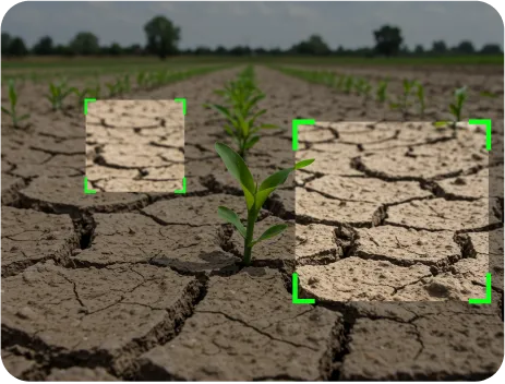
How does an agriculture crop management software integrate with weather forecasting for smarter irrigation planning?
Users can overlay real-time and forecasted weather data with field maps, soil zones, and crop stages. The software enables scheduling irrigation events based on rainfall predictions, evapotranspiration models, and soil moisture thresholds. Threshold-based alerts and irrigation logs enable field teams to make zone-specific decisions and minimize manual oversight.
What capabilities exist in crop management systems for managing multiple crop types across multiple locations?
Users can create crop-specific plans by field, variety, and location, defining input schedules, assigning equipment, and tracking task completion independently. The platform supports multi-farm hierarchies, localized treatment plans, performance comparisons, and consolidated reporting across geographies. Each field's unique crop cycle is fully configurable with traceable activity logs.
How do crop management platforms support compliance reporting and audit readiness for regulatory standards?
Every action, such as pesticide spray, irrigation, or harvest, is logged with timestamps, user identity, and geographic location. The system auto-generates reports aligned with regulatory formats (e.g., FSMA, GAP, organic certifications). You can export input usage summaries, field histories, or equipment logs for audit reviews and maintain version-controlled digital records.
What mobile and offline features are available for on-field data entry in remote farming zones?
Field teams can log completed tasks, input applications, observations, and photos directly from a mobile app. The offline mode enables all entries to be stored locally, including time and location metadata. Once reconnected, data syncs with the central system, automatically updating dashboards, task status, and compliance logs.
Can ERP systems be integrated with agriculture crop management platforms for end-to-end visibility?
Yes. The most advanced crop management platforms support ERP integration through APIs or middleware connectors. This allows synchronization of inventory, procurement, labor, and financial data with field operations. You can push real-time crop activity, input usage, and yield projections into ERP systems to align planning, accounting, and logistics across your agriculture enterprise.
How do crop risk management features help in forecasting yield loss and improving financial planning?
The platform combines historical yield trends, crop health indices, weather variability, and in-season field observations to generate yield risk models. These tools flag vulnerable zones, simulate potential losses, and quantify financial exposure. The crop planning software can be used to adjust input plans, optimize insurance coverage, and model ROI scenarios based on real-time risk data.
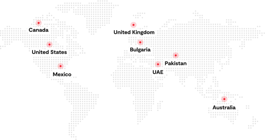
Serving the Agriculture Industry Globally Since 2004
Contact Us
Start Your Success Journey With Folio3 Today!
Get a Head Start with fast & scalable AgTech Solutions
Get a Free Consultation Within 24 Hours, with a No-Obligation Ballpark Estimate
Error: Contact form not found.
Our Expertise
20+ years in the AgTech Industry
600+ projects completed worldwide
A quality management system compliant with ISO 9001, ISO 27001 & 27701