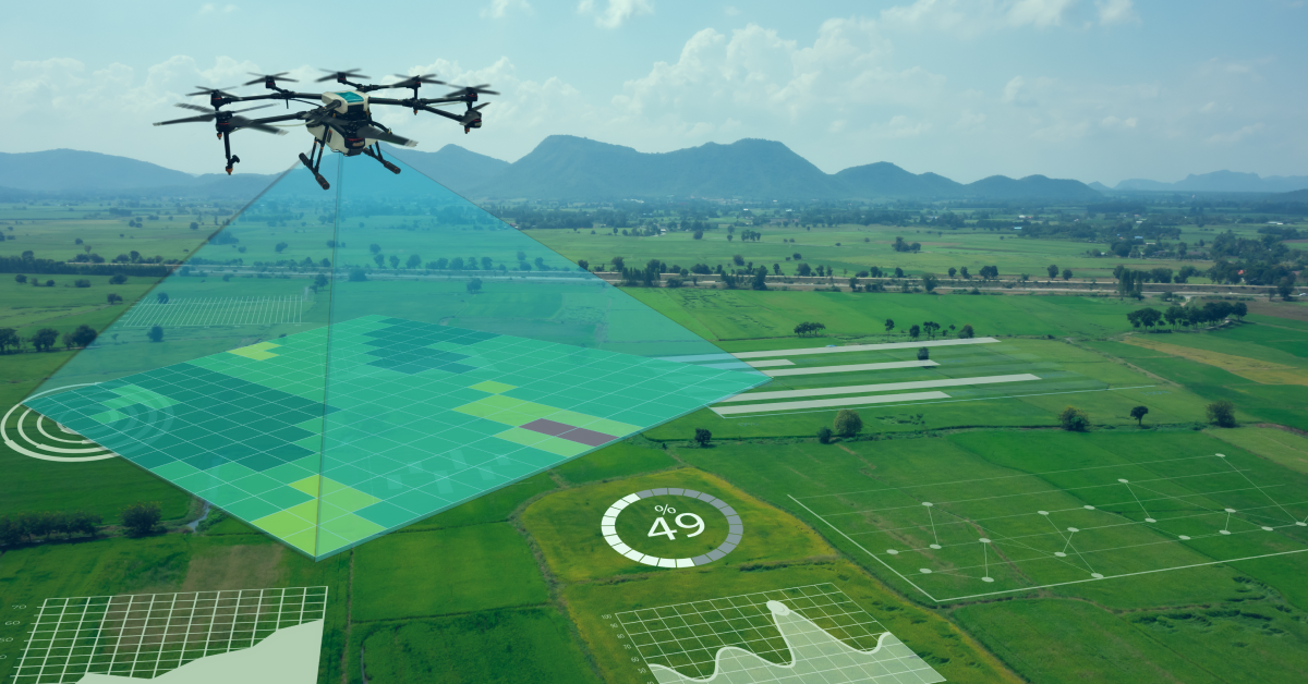

Not long ago, drones were little more than weekend toys buzzing around backyards. Today, they have evolved into multifunctional flying tractors capable of spraying fertilizer, sowing seed, and monitoring livestock across thousands of acres. Modern agricultural drones can carry payloads weighing up to 100 kg and be deployed within minutes of purchase.
With the global agricultural drone market projected to grow from USD 2.63 billion in 2025 to USD 10.76 billion by 2030 at a CAGR of 32.6%, it is clear that drones for farming are no longer optional; they are becoming essential. This guide walks you through the core applications, benefits, challenges, types, implementation steps, and future trends of farming drones so you can decide how best to put them to work on your operation.
Why Drones Are Becoming Essential Tools in Farming
Global food demand is rising, arable land is shrinking, and labour shortages are squeezing margins everywhere. These pressures are pushing farmers toward smart farming drones that deliver precision at scale. Here is why drones in farming and agriculture are gaining ground so quickly:
- Explosive global adoption: Agricultural drones diffused first from East Asia to Southeast Asia, then to Latin America. Finally, they are here in North America and Europe, reversing the traditional technology-adoption pattern.
- Skyrocketing U.S. registrations: FAA agricultural drone registrations jumped from roughly 1,000 in January 2024 to around 5,500 by mid-2025. However, the actual usage is believed to be higher due to underreporting.
- Versatility across tasks: Today’s farming drones handle spraying, fertilizing, seeding, mapping, livestock monitoring, and even fish-feed distribution. It makes them relevant to virtually every type of agricultural operation.
- Falling costs and easier operation: Enterprise-grade drones are now more affordable than ever, and many units are flight-ready straight out of the box, eliminating the steep learning curve that held back earlier adoption.
- Sustainability imperative: Targeted drone application can reduce pesticide usage by 30–50% compared to conventional methods, aligning with global sustainability goals.
How to Use Drones in Agriculture – Core Applications of Agricultural Drones
The uses for drones in agriculture go far beyond aerial photography. Below are the primary applications that are reshaping farms worldwide.
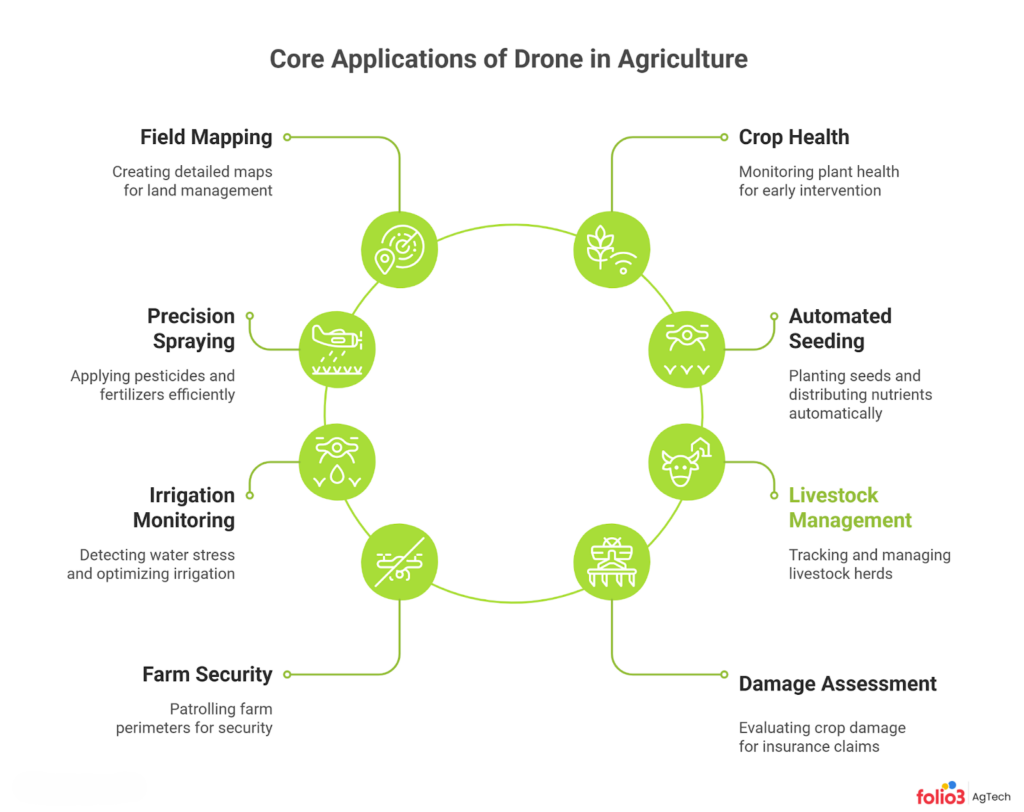
High-Resolution Field Mapping & Soil Analysis
Before you plant a single seed, understanding your land is crucial. Fixed-wing drones equipped with LiDAR and multispectral sensors can map hundreds of acres in a single flight, producing 3D elevation models, drainage maps, and soil variability charts. These datasets help you identify compaction zones, low-lying areas prone to waterlogging, and soil-type boundaries.
As a result, it enables you to plan drainage tile placement, adjust seeding rates by zone, and create prescription planting maps. All of these tasks used to require expensive survey crews or satellite imagery with limited resolution and multi-day turnaround times. With a drone, you can have actionable maps the same afternoon.
When combined with precision agriculture technology platforms, drone-generated maps feed directly into variable-rate equipment, enabling zone-specific input management from day one.
Crop Health Monitoring
Multispectral and NDVI (Normalized Difference Vegetation Index) cameras mounted on drones detect chlorophyll stress, nutrient deficiencies, and disease hotspots well before symptoms are visible to the naked eye. Instead of spending days walking fields, you can fly a drone over your entire operation in an hour and pinpoint exactly which zones need attention.
This kind of early detection is a transformation, as drone-based monitoring helps farmers intervene at early stages of pest and disease outbreaks, reducing crop losses significantly. Pairing drone imagery with smart farming technology closes the gap between data collection and actionable decisions.
Precision Spraying & Variable Rate Application (VRA)
Precision spraying is arguably the most commercially impactful use of drones in agriculture today. Multi-rotor sprayer drones equipped with GPS, RTK positioning, and ultrasonic terrain-following sensors apply herbicides, fungicides, and insecticides only where they are needed. A study found that UAV spraying systems can achieve a 46–75% reduction in pesticide usage compared to conventional ground-based application.
The safety benefits are equally important. Drone application reduced operator pesticide exposure by 90–99% compared to handheld spray equipment. For farmers who want to take precision fertilization to the next level, combining VRA drones with soil-test data is a game-changer.
Automated Seeding & Nutrient Distribution
Drones are no longer limited to liquid payloads. Specialized seeder drones broadcast cover crop seeds, rice seeds, and granular fertilizer over fields that are too wet for ground equipment or inaccessible to tractors due to steep terrain. It is especially valuable in no-till and regenerative farming systems where disturbing the soil is undesirable.
In flood-prone regions of Asia, drone seeding has become the standard approach. It cuts planting time from days to hours and eliminates the need for labourers to wade through waterlogged paddies. Some operations also use drones to distribute biological pest-control agents, such as parasitic wasps, across fields with pinpoint accuracy.
Irrigation Monitoring & Water Stress Detection
Thermal cameras on drones measure canopy temperature variations that indicate water stress long before wilting becomes visible. By overlaying this data with soil-moisture sensor readings, you can identify under-irrigated zones, leaking pivots, clogged drip lines, or even underground pipe breaks within minutes. Addressing these issues promptly prevents yield loss and conserves water, an increasingly critical concern as climate variability intensifies.
For centre-pivot irrigators, a single thermal flight can reveal nozzle malfunctions across the entire span, eliminating the time-consuming walk-through inspection. Integrating drone-based moisture maps with IoT-enabled farm systems creates a closed-loop irrigation management cycle that responds to actual field conditions rather than guesswork.
Livestock Management & Tracking
If you manage cattle across vast rangelands, drones for livestock management equipped with thermal and RGB cameras can locate animals and monitor herd distribution. Plus, it detects health anomalies such as lameness or fever by identifying heat signatures. It drastically reduces the time and labour involved in horseback or ATV-based checks, especially on rugged terrain. Drones are also being used to gently guide livestock during mustering, replacing the noise and stress of helicopters with a quieter, lower-altitude approach that keeps animals calmer and reduces injury risk.
For operations already using livestock management software, drone-captured data can feed directly into herd records, connecting aerial observations with individual animal health histories and breeding schedules.
Farm Security & Perimeter Patrol
Theft of equipment, fuel, and livestock remains a serious concern on rural properties. Autonomous patrol drones can fly pre-programmed perimeter routes at scheduled intervals, streaming live footage to your phone or farm management dashboard. Night-vision and thermal capabilities allow them to detect intruders, stray animals breaking through fences, or even fire outbreaks long before a ground patrol would notice.
For ranches spanning thousands of acres, a single drone can cover ground that would take hours by vehicle. Some producers are also pairing security drones with motion-activated alerts from ground sensors to create a layered surveillance system that runs 24/7.
Damage Assessment for Crop Insurance
After a hailstorm, flood, or pest outbreak, documenting damage quickly and accurately is critical for insurance claims. Drones capture geo-tagged, timestamped imagery that provides objective evidence of crop loss across affected fields. Insurers and adjusters increasingly accept drone data as part of the claims process, which speeds up payouts and reduces disputes.
By comparing pre-event and post-event drone imagery, you can quantify the exact acreage and severity of damage with far greater precision than manual walk-throughs allow. This application alone can justify a drone’s cost in a single season for operations prone to weather events.
Benefits of Using Drones in Agriculture
The advantages of drones in agriculture extend across efficiency, economics, safety, and sustainability. Here is what the evidence shows:
- Increased efficiency: Drones survey large areas in a fraction of the time it takes for ground-based scouting. Real-time data delivery means you can act before pests or diseases spread beyond manageable levels.
- Resource optimization: Variable-rate application guided by drone imagery can reduce water usage for spraying by up to 90%, while targeted inputs lower chemical costs substantially.
- Improved sustainability: Less chemical runoff means healthier waterways and soil biology. Drone-guided precision fertilization also reduces nitrous oxide emissions from over-application, contributing to climate-smart farming.
- Enhanced decision-making: High-resolution multispectral imagery supports data-driven planning, yield prediction, and post-season field analysis, turning reactive farming into proactive management.
- Better safety: Drones minimize the need for operators to handle hazardous chemicals directly or traverse dangerous terrain. Operator pesticide exposure drops by 90–99% when spraying is carried out via drone rather than handheld equipment, based on published field measurements.
- Economic returns: Although upfront costs can be significant, drones that improve yields by even 5–10% while cutting chemical inputs deliver a strong return on investment, often within one or two growing seasons.
Together, these benefits transform farm management from a reactive, calendar-driven process into a proactive, data-driven operation equipped to meet rising food demand sustainably.
Challenges and Considerations for Using Drones in Agriculture
No technology is a silver bullet. Here are the realistic challenges you should weigh before investing in drones for your farm:
- Initial investment: High-quality spraying drones with RTK GPS and multispectral sensors can cost anywhere from USD 10,000 to USD 30,000+. Software subscriptions and maintenance add to the total cost of ownership, which can be steep for small operations.
- Regulatory compliance: In the U.S., commercial drone operation requires an FAA Part 107 Remote Pilot Certificate, and agricultural spraying often involves additional state-level pesticide applicator permits. Many countries have their own certification requirements, altitude restrictions, and no-fly zones near airports. Regulations are evolving rapidly, so staying informed through industry associations and your local extension office is essential.
- Technical expertise: Flying a drone is the easy part. Interpreting NDVI maps, calibrating spray nozzles, and integrating data into farm management platforms requires training and ongoing skill development.
- Weather and operational limits: Strong winds, rain, and extreme temperatures ground drones. Battery life limits flight time to roughly 15–40 minutes per charge for multi-rotor models, restricting single-flight coverage on large fields.
- Privacy and data security: Aerial cameras capture high-resolution imagery that may include neighbouring properties. Following data-handling best practices and respecting boundary privacy is essential.
- Risk of over-reliance: Drones are tools, not substitutes for agronomic knowledge. Over-dependence on technology without foundational soil science and crop management understanding can lead to costly mistakes.
To mitigate these drawbacks, start small with one or two high-value use cases, partner with a drone service provider if capital is limited, and stay current with evolving regulations. Organizations like your local extension service can also be excellent resources for hands-on training.
Types of Agricultural Drones & Precision Technologies
Choosing the right platform depends on your operation’s size, terrain, and primary use case. Here are the main categories of precision farming drones:
- Multi-rotor drones: The most common type for agricultural use. They offer excellent hovering stability, vertical take-off and landing, and precise manoeuvrability. It is ideal for spraying, spot-checking, and short-range imaging missions. Flight time typically ranges from 15 to 40 minutes.
- Fixed-wing drones: Designed for long-range mapping and survey missions. Their aerodynamic design supports flight times of 60+ minutes and coverage of several hundred acres per flight. It is well-suited for large row-crop operations that need broad field maps.
- Hybrid VTOL drones: These combine fixed-wing range with multi-rotor take-off agility. They transition between hover and forward flight, offering the best of both worlds for operations that need both precision and coverage.
- Specialized sprayer drones: Engineered to carry large liquid or granular payloads. Models like the DJI Agras T50 offer 40–50 kg capacity with intelligent route-planning and obstacle-avoidance systems built in.
Key sensor options: RGB cameras for visual scouting, multispectral sensors for NDVI and crop health, thermal cameras for irrigation and livestock monitoring, LiDAR for terrain mapping, and hyperspectral sensors for advanced soil and plant analysis.
Multi-Rotor vs. Fixed-Wing vs. Hybrid VTOL: Quick Comparison
| Feature | Multi-Rotor | Fixed-Wing | Hybrid VTOL |
| Flight Time | 15–40 min | 60–120 min | 45–90 min |
| Payload | 5–50 kg | 1–5 kg | 2–15 kg |
| Best For | Spraying, spot imaging | Large-area mapping | Mixed tasks, mid-range |
| Launch | Vertical (any surface) | Runway or launcher | Vertical (any surface) |
Implementing Drones on Your Farm: A Step-by-Step Guide
Knowing that drones can help is one thing; putting them to work effectively is another. Here is a practical roadmap to get you started:
- Assess your needs: Start by identifying your top one or two pain points: crop scouting, spray precision, mapping, livestock tracking, and determine which data you need most urgently.
- Evaluate costs and ROI: Compare the economics of purchasing your own drone versus hiring a drone-as-a-service (DaaS) provider. For operations under 500 acres, DaaS often makes more financial sense initially. Leasing is another viable option.
- Choose the right platform: Match the drone type and sensor suite to your use case. Ensure that the platform is compatible with your existing farm management or agriculture ERP software so that data flows seamlessly between systems.
- Obtain training and certification: In the U.S., complete the FAA Part 107 exam for your Remote Pilot Certificate. If you plan to spray, check your state’s pesticide applicator requirements. Many manufacturers and extension services offer hands-on training courses.
- Develop flight plans: Use autonomous flight-planning software to create repeatable mission routes. Define altitude, speed, overlap percentage, and waypoints for optimal data capture. Consistent flight plans produce comparable data across seasons.
- Integrate with data management: Process drone imagery through GIS platforms to generate NDVI, thermal, and elevation maps. Feed these insights into your farm management dashboard. Integration with ERP systems in agriculture ensures that aerial data informs financial planning, input procurement, and compliance reporting.
- Start small and scale: Begin with one use case on a portion of your land. Measure results against your pre-drone baseline. Once you see clear value, expand to additional fields, tasks, and eventually swarm-drone operations for more extensive coverage.
This step-by-step approach minimizes risk while building your team’s confidence and capability over time.
Future Trends and the Role of Drones in Sustainable Agriculture
The future of drones in agriculture is accelerating faster than most farmers anticipate. Innovation is happening across hardware, software, regulation, and integration. Here are the trends you should watch:
- Swarm technology: Multiple drones operating in coordinated fleets will cover thousands of acres in a single mission. Swarm seeding and spraying are already being piloted in Asia, where fleet coordination algorithms assign individual drones to specific field zones in real time. This technology is expected to reach commercial scale in North America within the next few years, and it will dramatically reduce per-acre application costs.
- AI and machine learning: Onboard AI will enable drones to autonomously identify diseases, count plants, predict yields, and optimize flight routes in real time—eliminating the need for post-flight data processing in many scenarios. Edge computing chips already allow some models to classify weed species mid-flight and trigger spot-spray nozzles accordingly, reducing herbicide use further.
- Integration with ground robotics: Aerial drones will work in tandem with autonomous ground rovers for end-to-end field operations—drones scouting from above while robots handle weeding, sampling, or spot-spraying below.
- Advanced sensors and connectivity: Hyperspectral imaging, higher-resolution cameras, and 5G/6G connectivity will support real-time streaming of dense datasets, enabling faster decision cycles.
- Regulatory evolution: Beyond-visual-line-of-sight (BVLOS) flight restrictions are expected to ease in major markets, dramatically increasing the operational range and efficiency of farm drones.
- Integration with software and ERP: As farm data ecosystems mature, drone outputs will plug directly into agriculture ERP platforms and crop management software, creating unified dashboards that connect aerial intelligence with financial, operational, and compliance data.
These innovations align with the global adoption trajectory documented by MSU researchers and underscore a clear message: drones are integral to meeting future food demand while preserving the resources that make farming possible. Keeping up with the latest trends in agriculture will help you stay competitive as these technologies mature.
Comparing Drone Solutions to Traditional Methods
One of the most common questions farmers ask is: How do drones actually compare with the equipment I already own? The following table puts drone-enabled methods side by side with traditional approaches for common farming tasks, so you can see where the gains are most significant:
| Task | Traditional Method | Drone-Enabled Method | Key Advantage |
| Crop Health | Manual scouting on foot | Aerial multispectral imaging | Faster, full-field coverage; early issue detection |
| Spraying | Crop duster or ground sprayer | Multi-rotor precision sprayer | 46–75% less pesticide; 90–99% less operator exposure |
| Field Mapping | Tractor sensors or manual survey | Fixed-wing with LiDAR | Rapid, high-res 3D maps; terrain insights |
| Livestock Check | Horseback or ATV patrol | Drone with thermal camera | Reduced labour; detects health issues early |
| Seeding | Tractor-mounted planter | Seeder drone with GPS | Works on wet or hilly terrain; faster turnaround |
The comparison reinforces a recurring theme: drones excel where speed, precision, and safety matter most, while traditional methods remain viable for routine tasks on accessible terrain.
How to Choose the Right Drone for Your Farm
With dozens of manufacturers and hundreds of models on the market, selecting the right agricultural drone can feel overwhelming. The key is to avoid buying more technology than you need or less than your operation demands. Here is a practical framework to guide your purchase decision:
- Define your use case: Are you primarily imaging, spraying, seeding, or doing a mix? A multi-purpose sprayer drone is a different investment than a mapping-optimized fixed-wing.
- Evaluate key specifications: Payload capacity, flight time, operational range, battery life, and available sensor types should match your field size and task requirements.
- Prioritize software integration: Your drone’s data is only valuable if it connects to your decision-making systems. Look for compatibility with GIS platforms, farm management software, and agriculture ERP solutions. Open-source flight planners offer flexibility, while proprietary platforms may provide tighter hardware integration.
- Consider leading manufacturers: The DJI Agras series remains the global market leader for sprayer drones, offering 40–50 kg payloads and robust autonomous features. Other brands like XAG, Yamaha, and emerging startups each serve niche needs. Evaluate each based on your operation, not brand hype.
- Support and maintenance: Availability of replacement parts, warranty terms, after-sales service quality, and access to local training are often as important as the drone itself. A cheaper unit with poor support can cost more in downtime.
- Budget considerations: Entry-level mapping drones start at around USD 2,000–5,000. Serious sprayer drones with RTK and multispectral capability run USD 15,000–30,000+. Leasing and DaaS models let you test before committing to a purchase.
Conclusion
Drones in agriculture have evolved from niche gadgets to indispensable tools that touch every aspect of modern farming from seed to harvest, pasture to feedlot. They increase efficiency, cut input costs, reduce environmental impact, and enable the data-driven decision-making that today’s razor-thin margins demand. Whether you are managing a 200-acre vegetable operation or a 10,000-acre row-crop enterprise, there is a drone solution that fits your scale and budget.
Yes, challenges remain. Costs, regulations, and technical learning curves are real. But careful planning, phased adoption, and partnerships with experienced service providers can mitigate every one of these hurdles. With continued innovation in AI, swarm technology, and regulatory frameworks, the role of drones in agriculture will only grow.
If you are looking to integrate aerial intelligence with a connected farm management ecosystem, exploring platforms that unify drone data with herd records, field analytics, and financial planning.
FAQs
How Much Does an Agricultural Drone Cost?
Prices range widely depending on capability. Basic mapping drones start around USD 2,000–5,000, while advanced sprayer drones with RTK GPS and multispectral sensors can cost USD 15,000–30,000 or more. Drone-as-a-service providers offer per-acre pricing that eliminates the upfront investment.
Do I Need a License to Fly a Drone on My Farm?
In the United States, any commercial drone operation, including agricultural use, requires an FAA Part 107 Remote Pilot Certificate. Spraying applications may also require a state pesticide applicator license. Regulations differ internationally, so always check your country’s aviation authority requirements.
Can Drones Be Used on Small Farms?
Absolutely. While large operations benefit from fixed-wing mapping, small farms gain significant value from compact multi-rotor drones for targeted scouting, spot spraying, and livestock checks. The DaaS model makes drone technology accessible to operations of virtually any size without major capital outlay.
How Do Drones Improve Crop Yields?
Drones improve yields by detecting problems early: nutrient deficiencies, pest outbreaks, and water stress, so that you can intervene before damage spreads. Precision spraying also ensures inputs reach the right zones at the right rates, minimizing waste and maximizing crop response.
What Is the Difference Between a Multi-Rotor and Fixed-Wing Drone?
Multi-rotor drones hover in place and take off vertically, making them ideal for spraying and close-up imaging on smaller areas. Fixed-wing drones fly like aeroplanes and cover much more ground per flight, making them better for large-scale field mapping and survey missions.
What are the Benefits of Using Drones in Farming?
Drones in farming, including improved crop monitoring, precision in resource management, real-time data collection, and enhanced field mapping. They help farmers detect issues like pests, nutrient deficiencies, or irrigation problems early, reducing crop loss and increasing yields.
How are Drones Changing the Future of Agriculture?
Drones in farming is transforming agriculture by providing real-time data and enabling precision farming. They help monitor crop health, optimize irrigation, and detect pests early, leading to increased productivity and sustainability. As technology advances, drones will further enhance farm management and decision-making, driving efficiency and higher yields.